ALiVE.OS · ALiVE 3 Development
Mission Builder
Build an ALiVE mission from a few plain choices, then paste it into Eden as a preset.
New
ALiVE 3 is in active development. This briefing describes work in progress, and the behaviour it covers is subject to change as testing continues. Check the changelog at the foot of the page for what has moved recently.
On this page
Build a mission
Build a mission on the map, paste it into Eden
Pick a terrain and a kind of mission, choose the factions and where the fighting happens, and the builder writes an ALiVE preset. In Eden press Ctrl+Alt+P, choose Load from clipboard, and every module and area is placed and set.
- Simple mode walks you through six steps, starting from a mission that has been tested in game, or loads one of the presets that ship with ALiVE exactly as it ships.
- Advanced mode shows the same mission as its modules: every setting, modules added or removed, sync lines, and the areas, markers and objects on the map. You can paste in a preset you already have and change it. How to use it.
Maps for all the terrains ALiVE supports; a newly added terrain gets its map here too. Save your missions to your account from My missions; the one you are working on is also kept in this browser.
Sign in to use the Mission Builder
The builder keeps your missions in your account, so it needs you signed in with Discord. It's the same sign-in as the rest of these pages.
Terrain
Kind of mission
Each one is a starter preset, tested on the rig. You can change its factions, place and size next.
Sides and factions
Every faction the template uses, and what to use instead. A choice changes it on every module that names it.
Where
Alt+click the map to put your base there. In advanced mode, Ctrl+click picks things or drops them from what's picked and Shift+click adds them. Drag an area to move it (the modules that use it go with it), or drag its arrow to resize it.
There's no map for this terrain yet. Type the base position in metres from the map's south-west corner.
How big
Medium is the template as tested. Small and Large scale its group counts and move each placement's Force Size one step.
AI skill
For every AI faction the mission's commanders and placements use. The template's own setting is picked to start with.
Civilians
Support for players
Saves its progress
Yes saves the mission between sessions on the server, as the Persistent campaign template does: the AI, its commanders, logistics and the mission time, every 15 minutes.
Review
Then place your playable units at the base marker, and set respawn as you like. A preset can't carry units.
Submit to the preset library
A mission that works well can go on the Presets page for everyone. A person plays it before it's listed, so give it a few days; if it needs anything, we'll ask on Discord.
Modules
Every module in the mission. Open one for all its settings, under the headings Eden shows. On the map, click a module to open it and drag it to move it; Pick on the map syncs it with the next module you click.
Areas (map markers)
The area markers the mission brings with it, as Eden places them. A module uses one by putting its name in a setting such as TAOR Marker or Blacklist Marker, so renaming one here renames it in those settings too. Drag an area on the map to move it, or its arrow to resize it.
Markers
Point markers the mission brings with it, as Eden places them: an icon, a colour and a line of text, under a name. Right-click the map to add one where you want it, and drag it to move it.
Objects
The objects some modules work from, each synced to its module: rally points, recruitment points, Field HQs, the multispawn vehicle, and objects kept out of player logistics. Right-click the map to add one where you want it, and drag it to move it. The class is the object Eden places; change it to any object the game has.
Map key
Guide
How to use the advanced features
Simple mode needs no guide: pick, press Next, copy. Advanced mode shows the mission as Eden would, and most of it works the way Eden does. These are the parts that don't.
Advanced mode and its tabs
- Press Advanced beside Mode at the top. What you chose in simple mode is kept.
- The tabs are Terrain, Modules, Areas (map markers), Markers, Objects and Review. Each mode reopens on the tab you last left it on.
- The Terrain tab shows the terrain on its own, with nothing of your mission over it, so you can read the ground.
- Once you've changed something only advanced mode can show, it stays in advanced mode. Start over takes you back to simple.
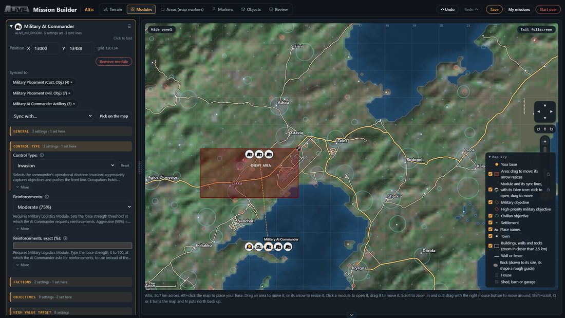
Modules
- Add one from the Modules tab (choose it, then Add module), or right-click open map and use Add module here.
- Open one by clicking it on the map or its card in the list. Drag it on the map to move it, or type X and Y on the card.
- Settings look the way Eden shows them: lists, tick boxes, and pickers with pictures for objects, vehicles and buildings. A picker also takes a class name typed in.
- A setting you've changed shows a Reset button beside it.
- Remove a module from its card, or click it and press
Delete. Its sync lines go with it.
Sync lines
- On a module's card, pick the other module in Sync with..., or press Pick on the map and click it.
- Or right-click a module on the map, choose Sync to... and click the other one.
Escor a click on open map cancels. - Remove a line with the × on its chip under Synced to, or right-click the module and use Remove its sync lines. Syncing the same two modules again also removes it.

Areas
- Press Add an area, or right-click the map and use Add an area here.
- Drag it to move it (modules that use it move too). Drag its arrow to resize it, down to 200 m.
- Its card sets the name, shape, size, angle and colour. Renaming it renames it in every module that uses it.
Markers
- Press Add a marker, or right-click and use Add a marker here. Drag it to move it, click it to open it.
- Choose its icon and colour from the buttons on its card. Eden markers only take Eden's own 16 colours, so a colour picked on the wheel is matched to the nearest with Use nearest.
- Name a marker
respawn_west,respawn_east,respawn_guerrilaorrespawn_civilianto make it that side's respawn point.
Objects
- Rally points (RP on the map), recruitment points (RC), Field HQs (HQ), multispawn vehicles (MSV) and objects kept out of logistics (L). Right-click the map and choose, for example, Add a rally point here, or use the Objects tab.
- Each is synced to its own module, and that module is added if the mission doesn't have it yet.
- Drag it to move it. Its row sets the object, from the picker or typed, its position and facing.
Picking several things at once
Ctrl+click to add or drop one,Shift+click to add one, or drag a box on open map.- Drag any of them to move them all.
Deleteremoves them all,Esclets go.
Pasting in a preset you already have
- Open My missions, paste into Paste a preset and press Load this preset. It can come from Eden (
Ctrl+Alt+P, Copy to clipboard), the Presets page, or somebody else. - It replaces what you're building, opens in advanced mode and goes onto its own terrain.
- To start from a preset that ships with ALiVE, use simple mode: the Kind of mission step has a list of them.
Switching terrain
- Pick another terrain, or a bookmark on another terrain, with a mission built, and you're asked first. Tick Save it first to keep the mission as it is in My missions, and tick what to clear: modules (with their sync lines and objects), areas, markers or objects.
- Whatever you keep moves with your base to the middle of the new terrain. It counts as a new mission there, so Save makes a new entry and the saved one stays on its own terrain.
Moving round the map
- Scroll to zoom, or use the +, − and slider at the side. Drag with the right mouse button to move round, or use the arrow pad.
Shift+scroll, orQandE, turn the map;Nputs north back up.- The ruler button measures distance and bearing: press it, then drag.
Escstops it. - Right-click open map for its grid and coordinates, each with a copy button, as well as everything you can add there.
Alt+click, or right-click and Put your base here, moves your base.

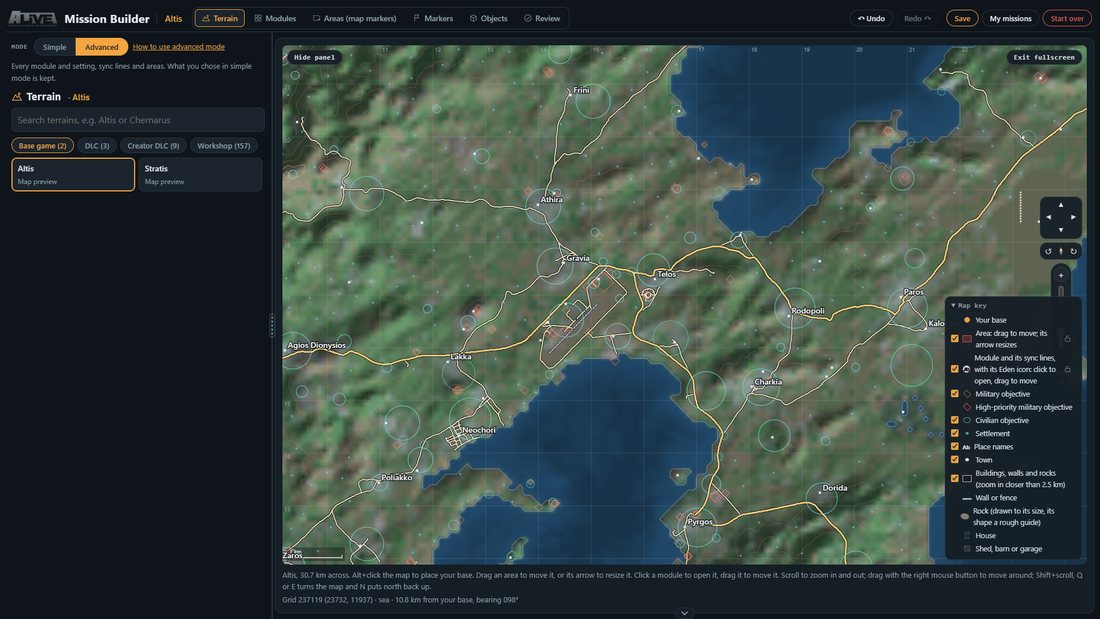
Reading the map
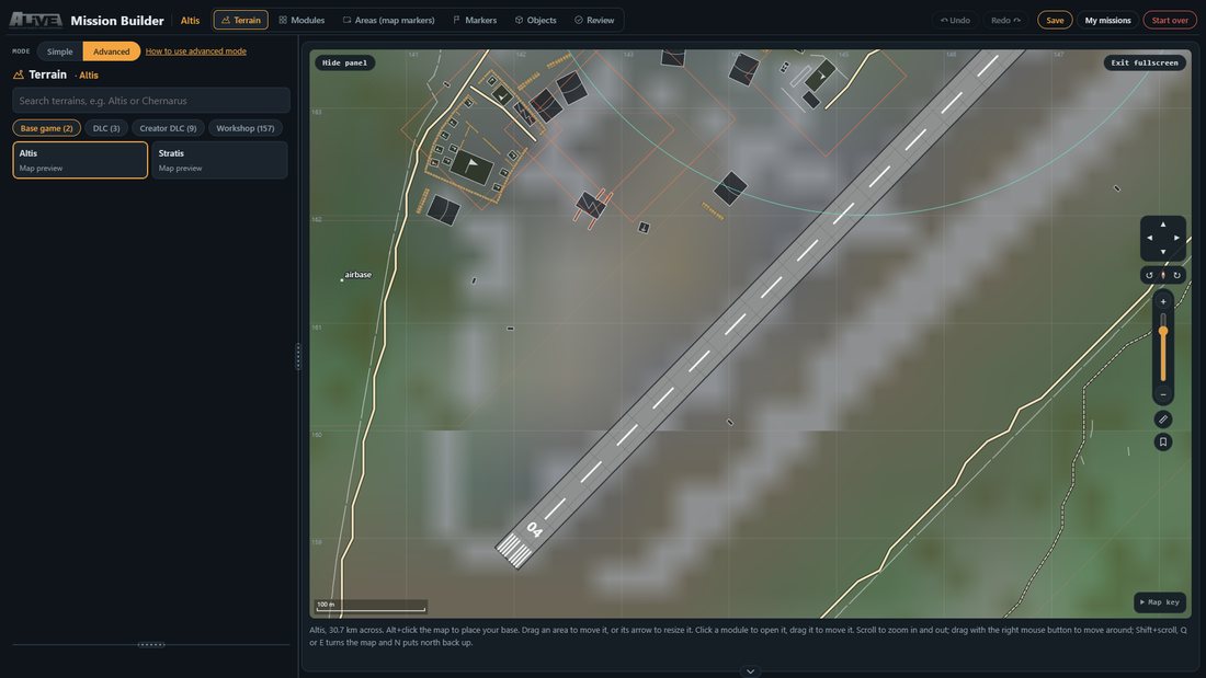
- Zoom in and buildings show as what they are: houses, sheds, hangars, bunkers, towers, piers (wooden or concrete), HESCO, trenches and the rest. Hover one for its name and size.
- Runways show what they're made of: concrete with its numbers, or a grass or dirt strip edged with white markers. Helipads show with the buildings; power lines and railways show from further out.
- The ground is coloured by what it really is: grass, dry grass, earth, rock, sand or snow.
- The Map key names every symbol, and its tick boxes show and hide each layer, and the zoom, arrow pad and ruler too.
Bookmarks
- The bookmark button at the side, or Bookmark this position on the right-click menu, keeps the terrain, the spot, the zoom and the turn under a name.
- Put them in folders, drag them between folders, rename them, and copy a bookmark's grid or coordinates. They're kept in your account, so they follow you to other machines.
Fullscreen
- Fullscreen gives the map the whole screen. The tabs move to the top bar, beside the terrain and the mission's name, with Undo, Save, My missions and Start over at the right.
- Hide panel gives the map the rest; picking a tab brings the panel back. The arrow under the map folds the help line away for a little more map.
- Drag the grip between the panel and the map to change the panel's width. A refresh comes back to the same terrain, view and fullscreen.

Undo, saving and starting over
- Undo and Redo at the top, or
Ctrl+ZandCtrl+Y, go back about ten steps. - What you're building is kept in this browser as you go. Save keeps it in your account, and My missions lists what you've saved. Save is greyed out until there's something to save.
- Start over clears the mission but keeps the terrain. It can't be undone.
Review, copy and submit
- The Review tab checks every setting and lists anything to fix first, such as a commander with no placement module synced to it.
- Press Copy preset, then in Eden press
Ctrl+Alt+Pand choose Load from clipboard. Place your playable units at the base marker afterwards: a preset can't carry units. - Submit to the preset library sends it in for others to use. Someone checks it before it's listed.

Changelog
Updates to this page
- 2026-11-01Module settings follow the same rules as Eden: a setting that doesn't apply to the choices already made hides, or greys out, and comes back the moment it does. Placing units at Objectives Only hides every unit section, for example. Each section's count shows how many of its settings aren't used.
- 2026-10-21Locking a layer in the map key shows on the cards too: every module, area or marker card of a locked layer shows its padlock closed, and clicking it says to unlock the layer in the map key. A thing locked on its own card stays locked when its layer is unlocked.
- 2026-10-21Each area, marker and module card has its own padlock: a locked one still shows and opens, but can't be dragged, resized, picked with the selection box or removed, the same as a locked layer in the map key, just for that one. Locks are kept with your mission. An area under 1 km across shows its size in metres.
- 2026-10-21Areas go down to 1 m across, dragged or typed (dragging stopped at 400 m, typing at 200 m), and each area's card has a Size slider that scales it from 1 m to 20 km, keeping its shape.
- 2026-10-21Rocks are drawn under everything on the map but the roads, so a boulder beside a house no longer lies on top of it.
- 2026-10-21Platforms, plinths and foundations are drawn under the buildings that stand on them, and no longer carry a name each, so the houses on Sahrani's stone platforms show and their names can be read.
- 2026-10-21Advanced mode's Modules tab has a Faction for each side box: pick a faction for BLUFOR, OPFOR or Independent and every module's faction settings for that side change to it at once, instead of one module at a time.
- 2026-10-19Objective outlines on the map are thinner, military and civilian alike.
- 2026-10-19Padlocks in the map key for markers, areas, modules and objects: a locked layer still shows and its things still open on a click, but nothing on it can be dragged, resized, picked with the selection box or deleted, and on a touch screen a drag over it moves the map instead. High-priority objective outlines are back to the same thickness as the rest.
- 2026-10-19High-priority military objectives are a heavier red-orange outline with no fill, so the buildings and roads inside them show through.
- 2026-10-19The map key scrolls when it's taller than the map. Paving has soft edges rather than 25 m steps. The map pass was missing buildings near the edge of each 500 m square it searches (on Altis 102,950 outlines now against 63,697 before, the airport terminal among those missed); every terrain is being mapped again, and each fills in as it's done.
- 2026-10-19Two new map layers when zoomed in closer than 3 km, each with its own tick box: Trees, from every tree on the terrain counted into 25 m squares so a wood shows its real edges, clearings and thick and thin parts; and Tarmac and concrete, the ground's own paved surface (airfields, aprons, yards and squares). They fill in terrain by terrain as the map pass reaches them.
- 2026-10-19Rocks on the map look like rocks: a rough stone shape with a darker edge and a lit face, rather than a flat box.
- 2026-10-19Roads stand out from the height lines: a brighter line on a dark edge (a light edge on the light theme), with tracks dashed, and the height lines are a fainter rust colour, thinner than any road.
- 2026-10-19Place names on the map are bolder and larger (a city larger again) and sit on a dark or light halo, so they read over towns, woods and outlines; they have their own Place names tick box in the map key.
- 2026-10-19The map turns. Twist two fingers on a phone or tablet (a pinch alone won't turn it), use the new turn control under the move buttons (15 degrees a press, the compass puts north back up and points north while the map is turned), or Shift+scroll, Q and E with a mouse, and N for north up. Everything turns with it, from the terrain, roads and outlines to areas, markers and the grid; names and icons stay upright, and dragging, zooming and picking work the same on a turned map. Turn control is a tick box in the map key.
- 2026-10-19Buildings on the map now carry the game's own names, as Eden gives them (Stone House (Small, Brown) rather than a name guessed from the model's file, which called it a shed), and the picture comes from the building's own class. Pointing at a building inside an objective's circle now shows the building, not the objective. Markers, areas, modules (with their sync lines) and objects each have a tick box in the map key, and a hidden one can't be picked up by mistake. The key also tells walls and rocks apart from buildings.
- 2026-10-19Every layer in the map key now starts switched on, Relief and Height lines included. Layers you switch off are still remembered.
- 2026-10-19The map names the buildings when zoomed in closer than 600 m (a church, a cargo HQ, a shop, a pier), and pointing at or tapping a building shows what it is, its size and its picture. New Height lines layer in the map key: every 50, 20 or 10 m by zoom, a heavier line every fifth, traced from the terrain's 100 m height grid so it is a guide rather than a survey. Building names fill in terrain by terrain as the map pass reaches them.
- 2026-10-19On an iPad or iPhone the terrain picture no longer slides out of line with the roads, towns and modules drawn over it, or stretches, when the map is zoomed out or moved past the edge of the terrain.
- 2026-10-19Touch controls on phones and tablets: drag one finger on open map to move it, pinch with two to zoom (and move while pinching), double-tap to zoom in, and press and hold for the menu a right-click gives, on a module or on open map. Dragging a module, area or object with a finger moves it, as with the mouse, and a tap on an objective, town, module or anything else on the map shows its details box. The note under the map says how on a touch screen.
- 2026-10-19Zoom in closer than 2.5 km and the map shows each building, wall and rock, taken from the terrain itself. An object placed inside a building, on a rock, in the sea or on ground steeper than 25 degrees is ringed red, its row says why, and Move to a clear spot puts it at the nearest clear place, as Eden's paste would. Review lists them too, along with Eden's own sync warnings: an AI Commander faction nothing places, and AI Commanders synced to each other. Terrains get their outlines as each is mapped.
- 2026-10-19The settings Eden fills from the game itself are pickers now, with the same lists: AA Classes, Drone Types, the CAS, Artillery, Ground and Transport vehicles, HVT and Recruiter classes and HVT Guards, Aircraft Types, Recruitment's units and vehicles, CQB's units and static weapons, roadblock and custom compositions, FOB hubs and garrison groups, the Logistics and Placement vehicle lists per faction, C2ISTAR's six auto-generated task factions and AI Skill's tiers. Each starts on the module's own side, shows pictures where there are any, and still takes a typed class. Object lists (FOB Never and Also Build, IED clutter, Rally Point and Command Point classes, Logistics lists) use the object picker. Opening a module no longer scrolls the page: the panel beside the map scrolls on its own.
- 2026-10-19Objects have a Choose object button (or click the picture): a list with pictures, pages of 24 and a search by name or class. It shows what suits the object (a Field HQ gets cargo houses, bunkers, tents and shelters; a recruitment point tables, desks and crates) from the mission's own mods first; Show everything and Every mod widen it and are remembered. Hover a picture to see it larger. Typing a class still works.
- 2026-10-19Access Item Categories on C2ISTAR, Combat Support and Player Resupply are tick boxes for all seven kinds of equipment, stored exactly as Eden stores them. Before, the setting was a text box holding LaserDesignators.
- 2026-10-19Settings now match Eden's own pickers: Who Can Dismantle, Air Tasking types, Commander Intel and COP sides, task types, Installation Types, the four installation interiors lists, Objective Objects (246, searchable), Animal Classes and Humanitarian Items are tick boxes stored exactly as Eden stores them; IED Integration is a list; Proximity Spawn shows locked on, as in Eden. Crowd and Ambient Vehicle factions list civilian factions, Artillery Faction has its (none) row, and faction lists only offer the sides Eden does. Settings Eden keeps hidden are no longer shown as text boxes.
- 2026-10-19The map's Key is now called Map key and starts open the first time you use the builder, so the legend is easy to find; close it and it stays closed. Under the builder there's a new How to use the advanced features section: short how-tos with pictures for modules, sync lines, areas, markers, objects, pasting a preset, moving round the map, saving, and review and submit. Asked for by A. Ares on Discord.
- 2026-10-19The Mission Builder is live: build an ALiVE mission on the map from a few plain choices, or every module and setting in advanced mode, then paste it into Eden as a preset. Maps for most terrains, with the rest being added.